Exhibit A
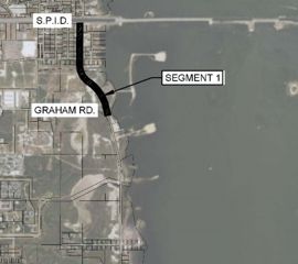
Project location map - Laguna Shores Road. Southern end of Segment 1.
Technical Report submitted to the Federal Highway Administration on June 8, 2021.
LAGUNA SHORES ROAD RESILIENCE & DURABILITY TO EXTREME WEATHER PILOT PROJECT REPORTIn March 2018, the Corpus Christi Metropolitan Planning Organization (MPO) received support from the Federal Highway Administration (FHWA) to deploy a nature-based shoreline protection feature to enhance the resilience to extreme weather of a roadway along the western shore of the Laguna Madre in Corpus Christi, Texas. The MPO was awarded $110,770 from FHWA to support design of an innovative, nature-based shoreline protection feature as part of an applied research deployment. A total of $22,154 (20%) was leveraged as in-kind, non-federal match in the form of partner staff time. Construction of the pilot nature-based shoreline protection feature, estimated to be $180,000, will be funded by the City of Corpus Christi but is not being proposed as match.
Laguna Shores Road, which runs along the western shoreline of the Laguna Madre between SH 358 and the Barney M. Davis Energy Center, is a major north-south thoroughfare in the Flour Bluff neighborhood of Corpus Christi. Laguna Shores Road may eventually provide an alternative for connectivity to Segment A of the seven-segment Regional Parkway Mobility Corridor (Regional Parkway), for which a Planning and Environmental Linkages (PEL) study was completed in 2016. The Regional Parkway will be a multi-modal facility that will help alleviate congestion on SH 358, will serve as a second route for evacuation of the most vulnerable parts of the City, and will enhance connectivity to the fastest growing portions of the community. This roadway was identified as a priority multi-modal corridor in the community’s Strategic Plan for Active Mobility, Phase 1 – Bicycle Mobility (2016).
The City of Corpus Christi is currently initiating the design phase of a project to rebuild three separate portions of Laguna Shores Road to improve the level of service and reduce susceptibility to inundation; construction was expected to begin in Spring of 2019. Under existing conditions, several locations along Laguna Shores Road are subject to periodic inundation under spring tide and other typical (non-storm) conditions. Likewise, shoreline erosion has historically undermined the roadway in multiple locations, which has direct negative impacts on project lifecycle, maintenance costs, and public safety. These locations are particularly susceptible to the impacts of storm surge and extreme weather events, and this vulnerability will increase in the face of sea level rise.
The southern end of Segment 1 of the reconstruction project (outlined in red on Exhibit A – Project Location Map, see below) is particularly vulnerable to extreme weather. At this location, there is no habitat buffer between the roadway and the open water of the Laguna Madre; the toe of the slope on the eastern side of the roadway is literally in the intertidal zone. This location is representative of significant portions of Laguna Shores Road, making it an ideal site for a pilot implementation of innovative shoreline protection techniques.
The Local Government led a collaborative effort and has:
Assess baseline habitat and shoreline conditions
Identify one or more innovative shoreline protection strategies that integrate engineering and ecological (habitat restoration/living shoreline) techniques
Construct a pilot shoreline protection project as part of the roadway reconstruction project
Monitor project effectiveness in terms of habitat development and shoreline condition to evaluate the utility of the pilot technique(s) to enhance the durability of other segments of Laguna Shores Road and other, similarly vulnerable transportation infrastructure
Project location map - Laguna Shores Road. Southern end of Segment 1.
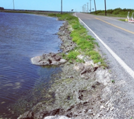
Non-Storm Condition - Southern end of Segment 1.
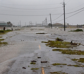
Laguna Shores Road after Hurricane Hanna made landfall south of Corpus Christi.
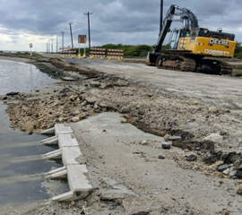
New drainage element in vicinity of future breakwater.
This pilot program is sponsored by the FHWA Office of Planning, Environment and Realty, in cooperation with the FHWA Office of Infrastructure.
Natural disasters have become increasingly damaging and problematic to transportation systems in many locations within the United States, affecting the performance of the trans-portation network and straining state and Federal funding for repair and maintenance. Addressing this critical issue is included in the U.S. Department of Transportation Draft Strategic Plan for FY 2018-2022*, which includes development of new tools to improve transportation infrastructure durability and resilience as a priority innovation area. It also states that infrastructure should be made resilient and durable to withstand extreme weather events. This pilot program will assist U.S. DOT and FHWA in achieving these strategic objectives, reducing future maintenance costs over the full life-cycle of transportation assets.
*U.S. DOT, 2017. https://www.transportation.gov/dot-strategic-plan